
Israel, a country with a rich and complex history, has undergone significant border changes since it declared statehood 75 years ago. Wars, treaties, and occupation have all played a role in shaping the land of Israel, and some areas remain undefined to this day. In this article, we will examine the fascinating journey of Israel’s borders, examining the key events and factors that have influenced their transformation.
The Ottoman Empire and the British Mandate
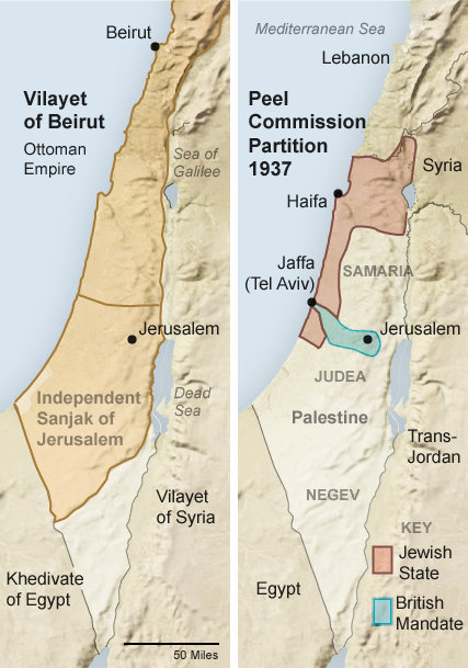
The land that would eventually become Israel had been dominated by the Ottoman Empire for centuries. However, after World War One and the empire’s collapse, the international community aimed to establish a new regional order. The territory known as Palestine, which included the land of Israel, was assigned to Britain to administer under a mandate from the League of Nations.
The British Mandate aimed to create “a national home for the Jewish people” in Palestine while ensuring non-Jewish communities’ civil and religious rights. This marked the beginning of a new chapter in the history of the land, as Jewish immigration increased in response to the rising anti-Semitism in Europe.
The United Nations Partition Plan
In 1947, due to the escalating tensions between the Jewish and Arab communities in Palestine, Britain sought the help of the United Nations to find a solution. The UN proposed a partition plan that suggested dividing Palestine into separate Jewish and Arab states, with Jerusalem and Bethlehem designated as international cities. Although the Jewish leadership accepted the plan, it was rejected by the Arab leaders.
The Birth of Israel and the 1949 Armistice Lines
On May 14, 1948, the Jewish community leaders in Palestine declared the State of Israel’s establishment. The next day, five Arab armies invaded Israel, sparking the War of Independence. The conflict resulted in several ceasefires, establishing armistice lines along Israel’s borders with its neighboring states.
These armistice lines were established in 1949, which created the Gaza Strip’s boundaries, occupied by Egypt, and the West Bank and East Jerusalem areas, populated by Jordan. Despite these developments, the Arab states surrounding Israel refused to recognize it, leaving its borders unclear.
The Six-Day War and the Expansion of Israel’s Borders
In 1967, during the Six-Day War, Israel significantly transformed its frontiers. Israel acquired control over the Gaza Strip, the Sinai Peninsula, the West Bank, East Jerusalem, and the Syrian Golan Heights in a rapid and decisive conflict. As a result, the territory under Israel’s control tripled in size.
After the war, Israel annexed East Jerusalem and declared the entire city, along with the Golan Heights, its capital. However, the international community did not acknowledge these moves until the United States shifted its official position under the Trump administration. Despite this change, most countries consider East Jerusalem and the Golan Heights occupied territories.
Land Borders Formalized: Egypt and Jordan
In 1979, Egypt became the first Arab country to recognize Israel. This recognition formalized the border between the two nations with a peace treaty. Israel withdrew its forces and settlers from the Sinai Peninsula, marking the completion of this agreement. In 1994, Jordan also recognized Israel, leading to the formalization of their long border. However, the borders with Lebanon and Syria are still unsettled, with the 1949 armistice line serving as Israel’s de facto northern border. The border with Syria has yet to be determined.
The West Bank, Gaza, and the Quest for Peace
The final borders and status of the West Bank, Gaza Strip, and East Jerusalem are supposed to be determined through negotiations between Israel and the Palestinians living under Israeli occupation. However, despite several attempts at talks, a sustainable solution has not yet been reached.
Even though Israel withdrew its troops and settlers from Gaza in 2005, the region remains under a de facto border arrangement. The United Nations considers Gaza and the West Bank a single occupied entity, and the official borders have not yet been defined.
The Gaza Strip: A Semi-Permanent Structure
Due to security concerns, Israel has built a semi-permanent structure around the Gaza Strip. Deep underground security fences and concrete walls have been constructed to prevent tunneling in response to tunnel attacks launched by Hamas militants in Israel in 2014. Despite these measures, security barriers above ground were breached by Hamas militants in a significant attack on October 7, 2023.
Conclusion
The borders of Israel have been shaped by a complex mix of historical events, conflicts, and negotiations. Starting from the Ottoman Empire to the British Mandate and from the United Nations Partition Plan to the Six-Day War, each milestone has played a significant role in redefining the land of Israel. However, many borders are yet to be settled, and there are ongoing discussions and challenges in determining the final status of the West Bank, Gaza Strip, and East Jerusalem. As the story of Israel’s borders unfolds, it is a stark reminder of the intricate tapestry of history and geopolitics in the Middle East.